 |
Navy – Merchant Marine Memorial
Washington, District Of Columbia |
Located in Lady Bird Johnson Park on Columbia Island, the Navy-Merchant Marine Memorial |
 |
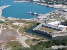
Fort Zachary Taylor Historic State Park
Key West, Florida |
Named after 12th president Zachary Taylor, the U. S. |
 |
Wright’s Chance/Queen Anne’s County Historical Society
Centreville, Maryland |
Dating back to the 1700s, Wright's Chance is a Colonial period plantation house. |
 |
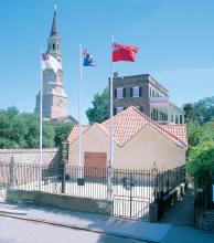
The Powder Magazine
Charleston, South Carolina |
Construction began on The Powder Magazine in 1712 and was completed by 1713, making it |
 |
Del Webb Sun Cities Museum
Sun City, Arizona |
The Sun Cities Area Historical Society/Del Webb Sun Cities Museum is dedicated to the p |
 |
Steamship Historical Society of America
East Providence, Rhode Island |
THE STEAMSHIP HISTORICAL SOCIETY OF AMERICA was established in 1935 as a means of bring |
 |
Tryon Palace
New Bern, North Carolina |
Tryon Palace is a modern recreation of the original palace, which served as the royal g |
 |
Hampton-Preston Mansion & Gardens
Columbia, South Carolina |
One of Columbia's oldest remaining historic houses, the Hampton-Preston Mansion was hom |
 |
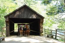
Old Sturbridge Village
Sturbridge, Massachusetts |
Old Sturbridge Village is the largest living history museum in New England, spanning o |
 |
Heritage Farm Museum And Village
Huntington, West Virginia |
Tour the entire village to get a glimpse of a craftsman at work in the Blacksmith shop |
 |
Mordecai Historic Park
Raleigh, North Carolina |
While at Mordecai, visitors can tour other historic structures which have been moved to |
 |
Old Florida Museum
St. Augustine, Florida |
What better way to compare one period of Florida history with another than through the |
 |
Historic Brattonsville
McConnells, South Carolina |
Historic Brattonsville is a 775-acre historic site that includes a Revolutionary War ba |
 |
Ah Tah Thi Ki Museum
Big Cypress Indian Reservation, Florida |
The Ah-Tah-Thi-Ki Museum on Big Cyrpess Reservation explore |
 |
Mount Calvert Historical And Archaeological Park
Upper Marlboro, Maryland |
Mount Calvert's rich archaeological and historical resources represent over 8,000 years |
 |
Sotterley Plantation
Hollywood, Maryland |
The oldest remaining Tidewater plantation, Sotterley is now a National Historic Landmar |
 |
Clarke County Historical Museum
Grove Hill, Alabama |
Housed in the historic Alston-Cobb house, the Clar |
 |
St. Clement's Island Potomac River Museum
Colton's Point, Maryland |
This museum overlooks and focuses on the history of St. |
 |
Riversdale House Museum
Riverdale Park, Maryland |
This beautifully restored 19th century estate, which offers tours to the public, was ho |
 |
Archibald Smith Plantation Home
Roswell, Georgia |
For over 150 years, the Smith’s Plantation Home has stood the test of time as The Civil |
 |
Destrehan Plantation
Destrehan, Louisiana |
Erected in 1787 by Charles Paquet, Destrehan Plantation was purchased by indigo planter |
 |
B&O Railroad Museum: Ellicott City Station
Ellicott City, Maryland |
The oldest standing railroad station in the United States houses this museum in histori |
 |
House In The Horseshoe
Sanford, North Carolina |
During the American Revolution, groups of citizen-soldiers called Whigs or revolutionis |
 |
Carnton Plantation And Battlefield
Franklin, Tennessee |
Carnton was built in 1826 by |
 |
Belmont Mansion
Nashville, Tennessee |
The moving spirit of Belmont Mansion was Adelicia Hayes Franklin Acklen Cheatham. |
 |
Poplar Grove Plantation
Wilmington, North Carolina |
|
 |
Arkansas Historic Preservation Program
Little Rock, Arkansas |
The Arkansas Historic Preservation Program is devoted to getting the citizens of Arkans |
 |
Beauvoir: The Jefferson Davis Home & Presidential Library
Biloxi, Mississippi |
The house was built by James Brown, a wealthy plantation owner from Madison County, Mis |
 |
Morven Museum & Garden
Princeton, New Jersey |
For more than 200 years Morven has played a role in the history of New Jersey and the n |
 |
Pebble Hill Plantation
Thomasville, Georgia |
The Main House was built in the 1930s in a Georgian and Greek Revival Architectural str |


